❄️ From Wildfire Severity to Snow Persistence
Parastoo Farajpoor and Mohammadreza Narimani* (corresponding author)
Frontiers in Forests and Global Change · Volume 9 · Article 2016172 · 4 November 2026 · Open access CC BY
Department of Biological and Agricultural Engineering · University of California, Davis
Why Creek Fire Snow Persistence Matters
Mountain snow links forest condition to the timing and availability of water across the western United States. Warming is already changing snow amount, duration, and seasonality, while wildfire increasingly overlaps Sierra Nevada landscapes that historically retained snow through winter and spring. For hydrologists, forest managers, and remote-sensing researchers searching for Creek Fire snow persistence, post-fire snowpack, or wildfire severity and snow, the practical question is not only “can we map snow after fire?” but “did fire change snow relative to comparable unburned terrain?”
Canopy removal can reduce interception and increase the fraction of snowfall reaching the ground, yet it also changes shading, longwave radiation, wind, and redistribution. Char on snow can lower albedo and accelerate melt. The same burned landscape can therefore show both greater accumulation and faster ablation. Satellite snow cover, snow disappearance date, snow depth, and snow water equivalent describe related but different quantities—so a high machine-learning score on one optical metric does not automatically prove a causal fire effect.
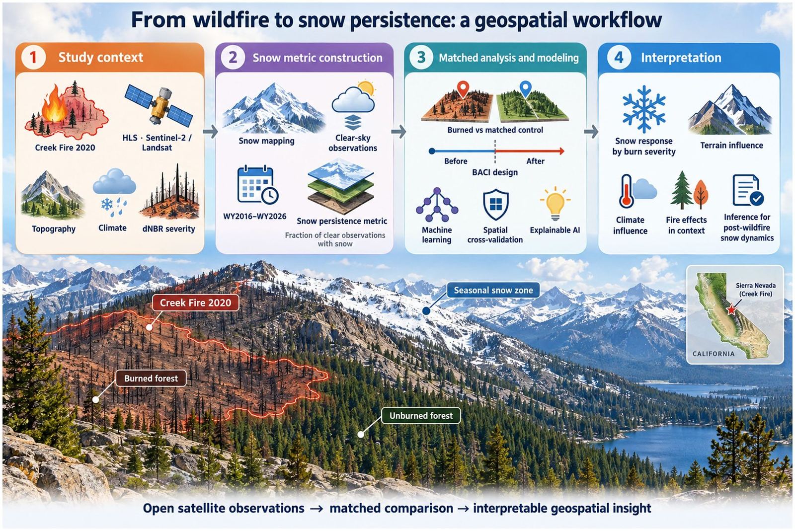
This open-access Frontiers study by Parastoo Farajpoor and Mohammadreza Narimani (corresponding author, University of California, Davis) builds an explainable multisource GeoAI framework for seasonal snow persistence after the 2020 Creek Fire. The analysis uses Harmonized Landsat–Sentinel-2 (HLS) observations for eleven water years (WY2016–WY2026) on a 500 m grid, matched before–after control–impact (BACI) comparisons, and spatially blocked machine learning with SHAP attribution.
Multisource GeoAI Framework for Post-Fire Snow
The workflow separates four tasks that are often conflated in wildfire remote sensing: (1) constructing a seasonal optical snow-persistence metric from HLS; (2) classifying spectral burn severity with Sentinel-2 dNBR; (3) estimating fire-associated change with matched BACI contrasts; and (4) asking whether terrain, climate, and fire descriptors can predict raw persistence versus the fire-adjusted anomaly under spatial cross-validation.
Seasonal persistence is defined as the fraction of clear-sky HLS observations classified as snow between 1 October and 30 July of each water year. Snow classification uses NDSI with green reflectance thresholds on Harmonized Landsat and Sentinel-2 collections. That metric tracks how often snow is optically detectable under clear skies—it is not snow water equivalent, and it is not the fraction of calendar days with snow.
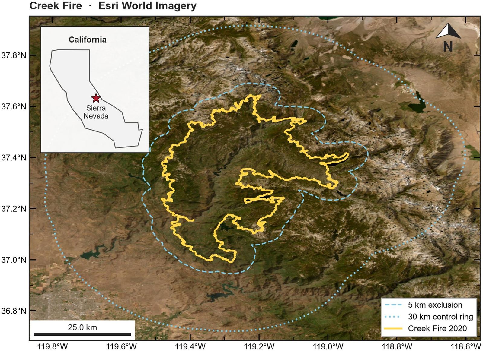
Creek Fire Study Area and Candidate Controls
The 2020 Creek Fire burned roughly 1,544 km² in California’s central Sierra Nevada, overlapping montane forests with substantial pre-existing drought- and bark-beetle-associated tree mortality. Five pre-fire and six post-fire snow seasons allow the post-fire record to be interpreted against both local baselines and contemporaneous unburned controls.
Candidate controls were drawn from a 5–30 km annulus beyond the perimeter: the inner buffer reduces boundary mixing, while the outer limit keeps a regional comparison pool. Geographic proximity alone was not treated as evidence of comparability. Matching used terrain and pre-fire snow conditions so that treatment and control cells start from similar physical settings before the fire year.
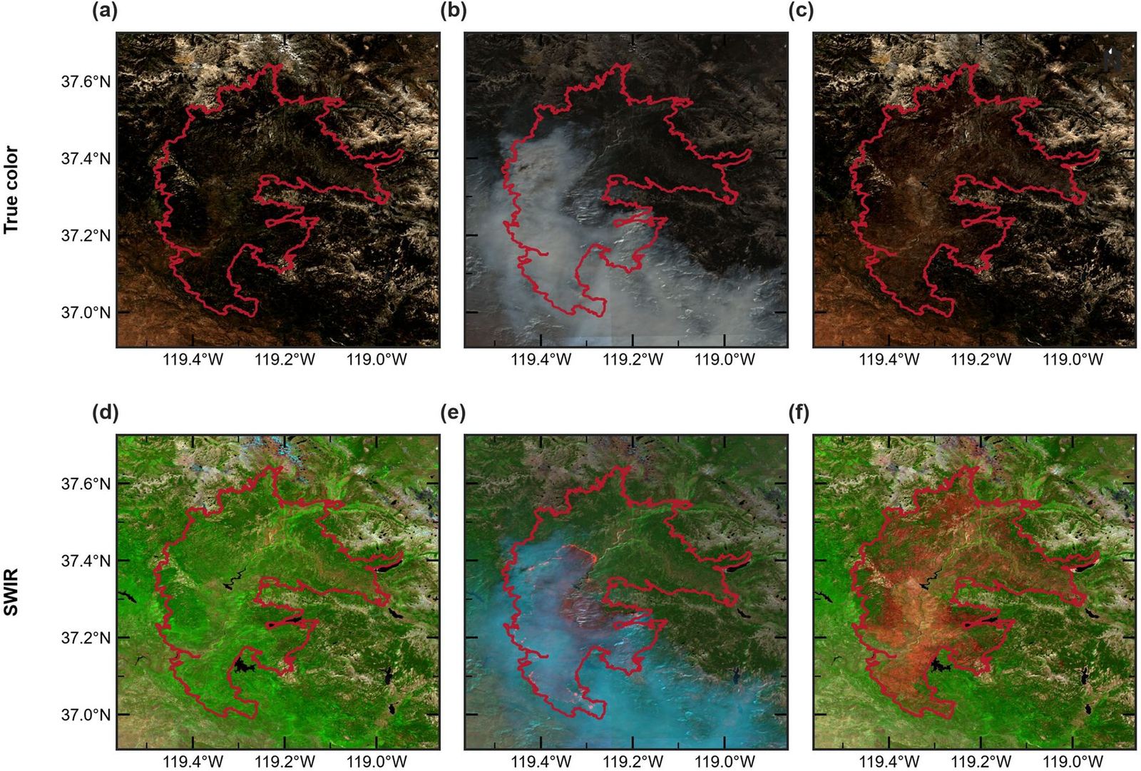
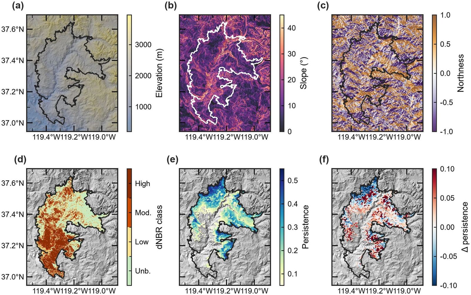
Terrain, Burn Severity, and Observed Snow Persistence
Eligible snow-zone cells required mean pre-fire persistence greater than 0.05, yielding 3,778 perimeter-internal treatment cells matched to unburned controls. Absolute standardized mean differences after matching were no greater than 0.047, indicating strong covariate balance on the matching variables.
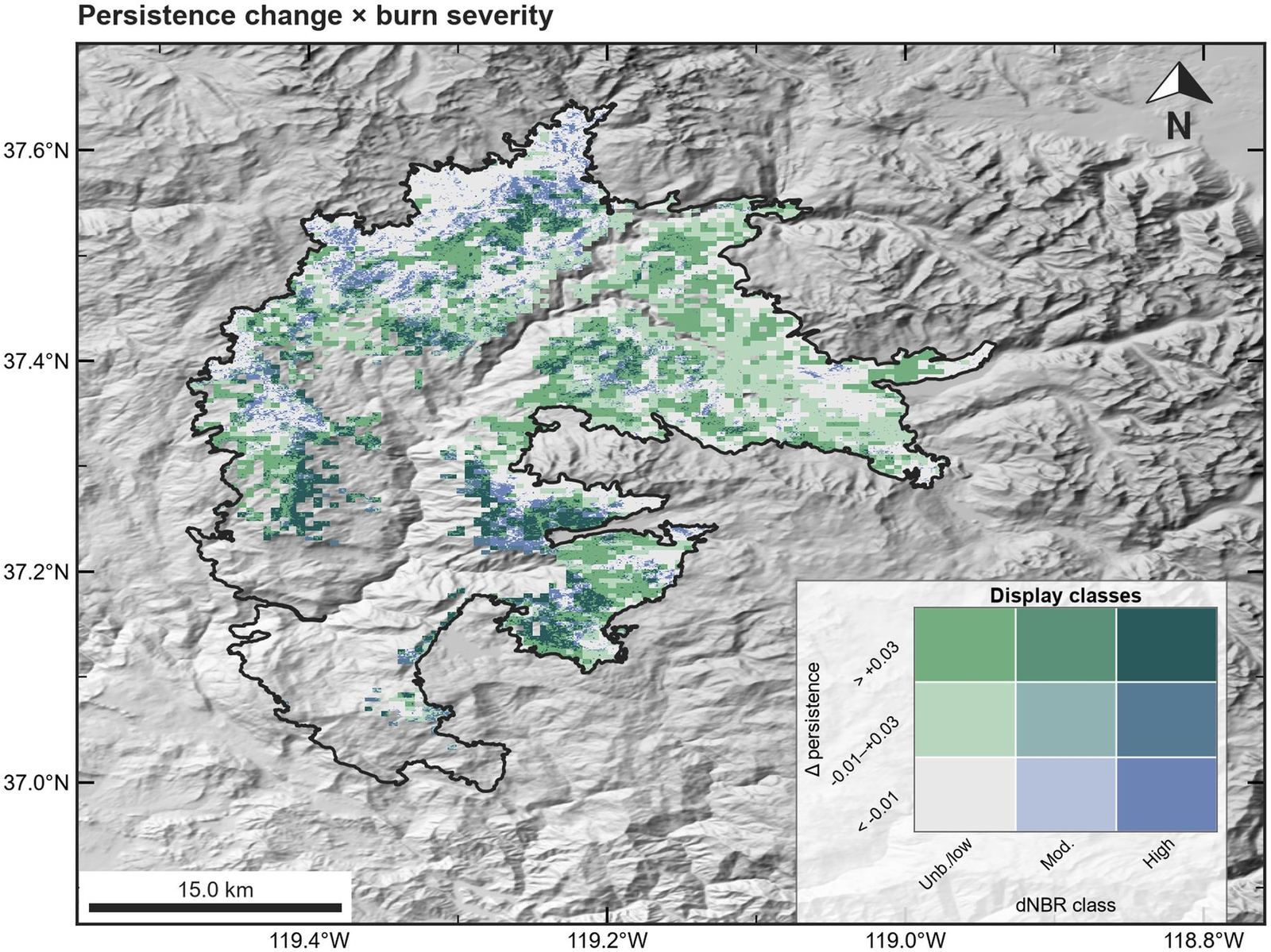
Elevation, slope, northness, and Sentinel-2 dNBR classes structure the burned landscape. Raw post-minus-pre persistence maps show where optical snow detection changed, but those raw maps are not control-adjusted: both burned and unburned cells can move together when climate varies from year to year. That is why the BACI design is central to claims about fire-associated change.
Matched BACI Contrasts by Wildfire Severity
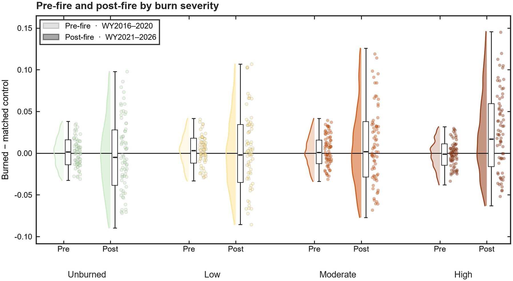
Across all matched cells, the landscape-average BACI contrast was only +0.0017, with a year-level 95% confidence interval from −0.023 to +0.027 (p = 0.88). Both treatment and matched-control cells increased in mean persistence after the fire; their similar movement is why the adjusted contrast is much smaller than a naive before–after difference inside the perimeter.
A clearer signal appears in the highest dNBR class (≥0.44; n = 448): the BACI contrast was +0.026 (2.6 percentage points), with a year-level interval of +0.002 to +0.050 and about 66% positive cell-level contrasts. Moderate severity showed a smaller positive contrast (+0.007); low-severity and internal low-change classes were not distinguishable from zero at the year level. Severity therefore identifies a class-level optical snow response more clearly than a strong, uniformly graded cell-level relationship (Spearman ρ between continuous dNBR and cell BACI ≈ 0.11).
HLS–MODIS Consistency for Seasonal Snow Monitoring
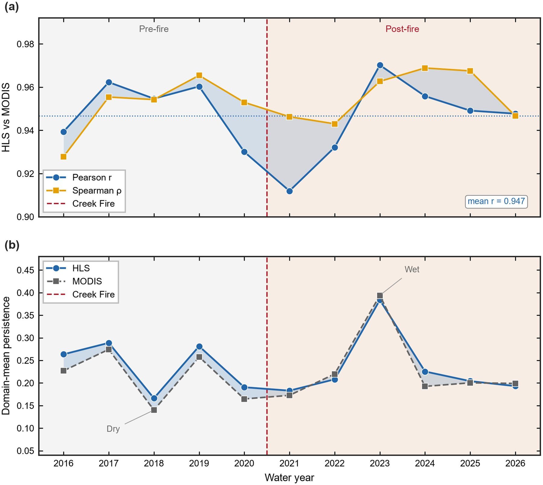
Annual spatial agreement between HLS and MODIS persistence was high throughout the eleven-season record (mean Pearson r = 0.947; range 0.912–0.970). Both products captured the same prominent annual contrasts, including the low-persistence WY2018 season and the high-persistence WY2023 season. HLS domain means were often slightly higher than MODIS, but the shared pattern supports using HLS as a consistent optical snow indicator for this GeoAI study.
Spatial Cross-Validation Separates Mapping from Fire Inference
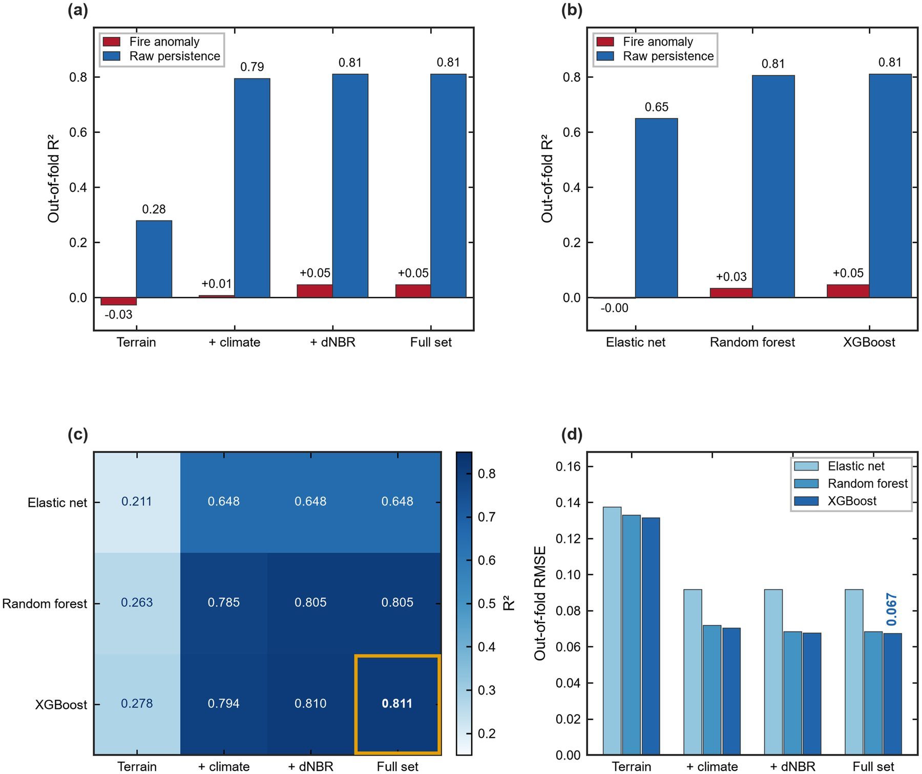
Under 5 km spatial-block cross-validation, XGBoost predicted raw post-fire persistence with out-of-fold R² = 0.811. The same model family applied to the fire-adjusted anomaly reached only R² = 0.046. In other words, environmental-state prediction can look excellent while disturbance-response prediction remains weak—exactly the distinction researchers need when searching for “explainable GeoAI wildfire snow” or “spatial cross-validation post-fire hydrology.”
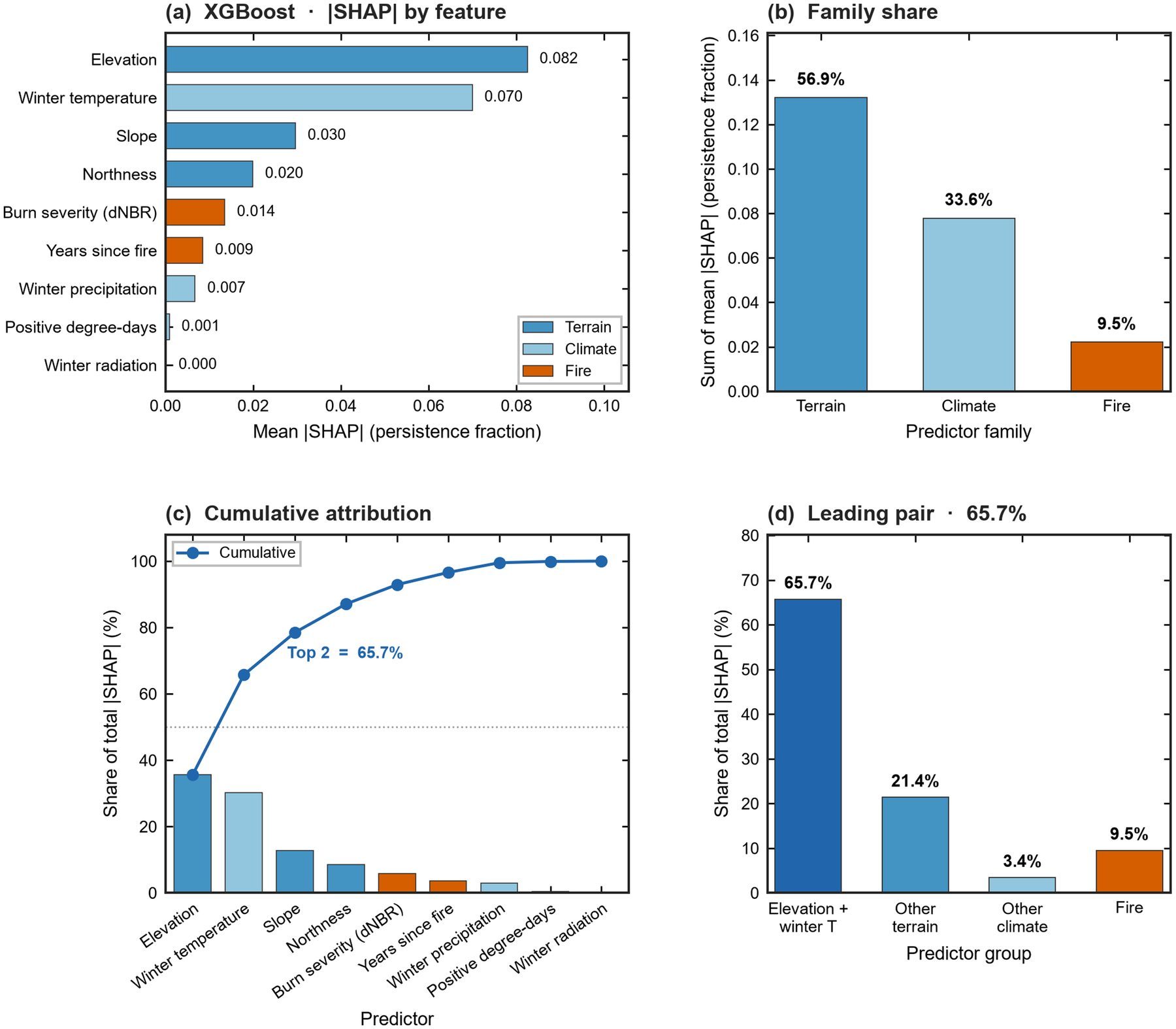
SHAP attribution for the raw-persistence model shows that elevation and temperature together account for 65.7% of mean absolute attribution. Terrain and climate dominate; fire descriptors contribute far less once the target is the matched anomaly. That pattern warns against treating a high R² snow map as evidence that fire “explains” snow change.
What the page summarizes
Design, key numbers, and figures for Creek Fire snow persistence GeoAI by Mohammadreza Narimani and Parastoo Farajpoor at UC Davis.
What to cite
The Frontiers in Forests and Global Change article (DOI 10.3389/ffgc.2026.2016172)—not this research card alone.
Who it helps
Researchers and managers searching for post-fire snow monitoring, matched BACI designs, and honest spatial ML evaluation.
Paper and Citation
Please read and cite the publisher version when you use this work. This research card is a visual summary only—it is not a substitute for the article, equations, or diagnostics in Frontiers.
Farajpoor, P., & Narimani, M. (2026). From wildfire severity to snow persistence: a multisource GeoAI study of the 2020 Creek Fire. Frontiers in Forests and Global Change, 9, 2016172.
DOI: 10.3389/ffgc.2026.2016172 · Open access under CC BY 4.0
Contact
Mohammadreza Narimani
PhD Candidate, University of California, Davis