🌳 GeoSAM2 Tree Segmentation
Digital Agriculture Laboratory | University of California, Davis
Deep Learning for Orchard Management
This project applies the Geospatial SAM2 model to automatically segment individual trees from high-resolution aerial imagery (Google & NAIP). By delineating each tree canopy and estimating canopy area, the tool supports orchard inventory, yield estimation, vigor analysis, and precision agriculture workflows.
Developed at the Digital Agriculture Laboratory, UC Davis as part of the UC Davis ESEARCH Program (Fall 2024), this tool leverages cutting-edge deep learning for agricultural applications.
How the Model Works
1️⃣ Image Input
Upload high-resolution aerial imagery from NAIP, Google, or other sources for tree detection analysis.
2️⃣ SAM2 Processing
The Geospatial SAM2 model automatically identifies and segments individual tree canopies using deep learning.
3️⃣ Bounding Box Refinement
Bounding-box assisted segmentation improves accuracy by focusing on individual tree regions.
4️⃣ Output Generation
Generate per-tree polygons with canopy area estimates for orchard management and analysis.
Before & After Tree Segmentation
Example showing raw aerial imagery and GeoSAM2 tree detection results with automatic canopy delineation.
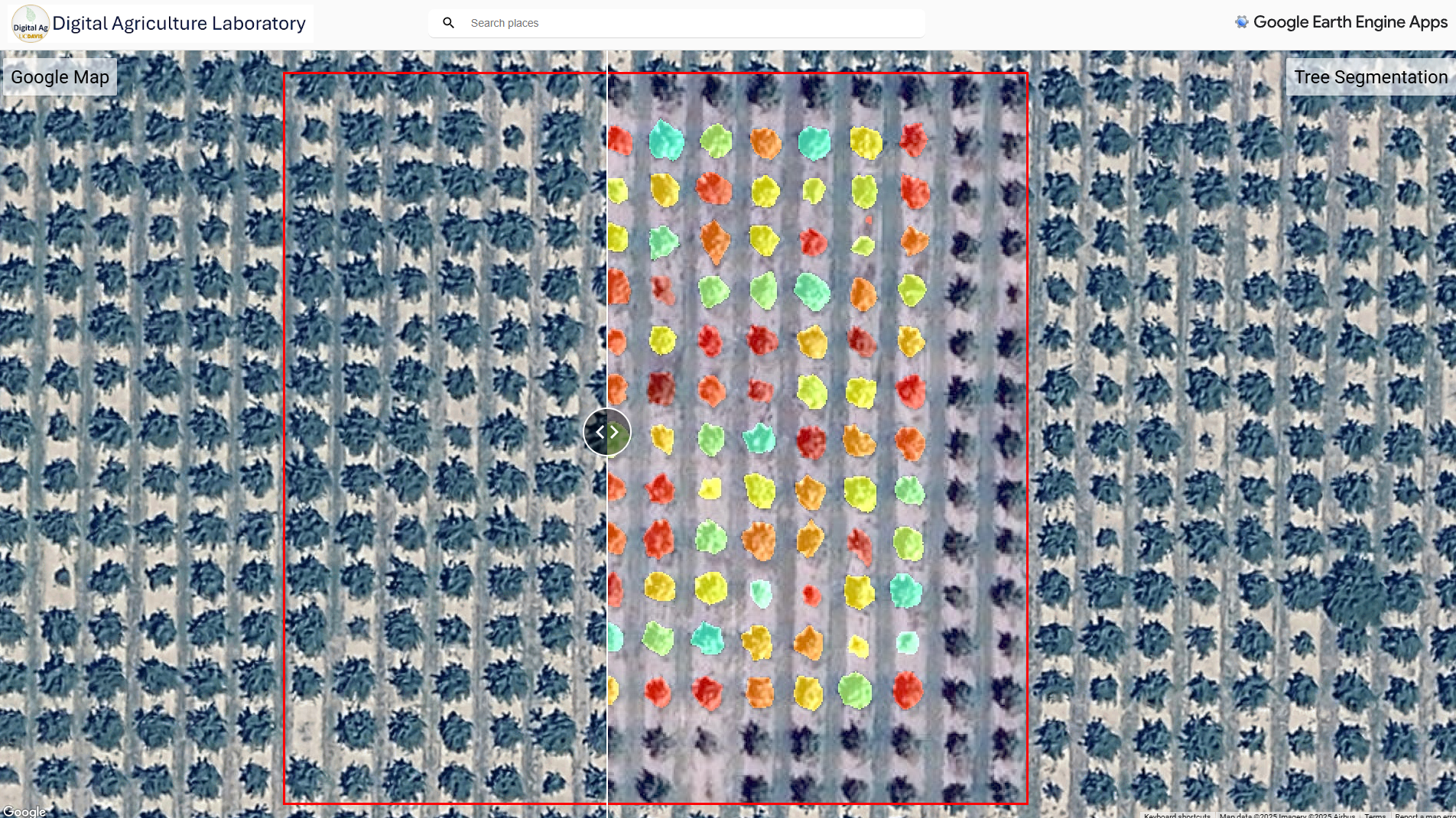
GeoSAM2 Tree Segmentation Results
Try the Interactive App
Explore tree segmentation directly in your browser using the deep learning visualizer
Technical Information
Deep Learning Framework
- Geospatial SAM2 (Segment Anything Model 2)
- Segment-Geospatial framework by Dr. Qiusheng Wu
- Bounding-box assisted segmentation
- High-resolution aerial imagery support
Framework: Segment-Geospatial SAM2
Orchard Applications
- Almond, walnut, pistachio orchards
- Citrus and olive groves
- Orchard inventory and tree counting
- Yield estimation and vigor analysis
- Precision agriculture workflows
Project Team
Development: Mohammadreza Narimani (PhD Candidate) & Sarbani Kumar (Undergraduate Mentee)
Program: UC Davis ESEARCH Fall 2024
Acknowledgment: Built on the Segment-Geospatial ecosystem by Dr. Qiusheng Wu and collaborators
Resources & Links
About the Developers
Mohammadreza Narimani (PhD Candidate) & Sarbani Kumar (Undergraduate Mentee)
University of California, Davis
Deep Learning • Remote Sensing • Digital Agriculture • Tree Segmentation • Precision Agriculture
Developing AI-powered tools for orchard management and agricultural automation at the Digital Agriculture Laboratory at UC Davis.
📧 mnarimani@ucdavis.edu | srbkumar@ucdavis.edu
🎓 Google Scholar Profile