🌿 GEE Satellite Plant Traits Visualizer
Collaboration with Alireza Pourreza
Digital Agriculture Laboratory | University of California, Davis
Interactive Plant Trait Monitoring
This Google Earth Engine application enables real-time visualization of satellite-derived plant traits anywhere in the world. Draw a polygon over your field or region of interest and instantly explore Leaf Area Index (LAI), canopy and leaf chlorophyll content, canopy and leaf water content, canopy and leaf dry matter, NDVI, and Landsat 8 thermal data using Sentinel-2 and Landsat imagery.
Developed at the Digital Agriculture Laboratory, UC Davis, this tool supports researchers, growers, and students in precision agriculture and environmental monitoring applications.
How to Use the App
1️⃣ Select Date Range
Choose your date of interest (the app uses a 3-month window around it for optimal data availability).
2️⃣ Draw Your Region
Use the drawing tools to create a polygon over your field or area of interest anywhere in the world.
3️⃣ Choose Plant Trait Layer
Select from LAI, NDVI, Canopy Chlorophyll, or Thermal layers to visualize different crop characteristics.
4️⃣ Analyze Results
View results with dynamic legends and cloud-masked imagery for accurate crop condition assessment.
Example: Davis, California
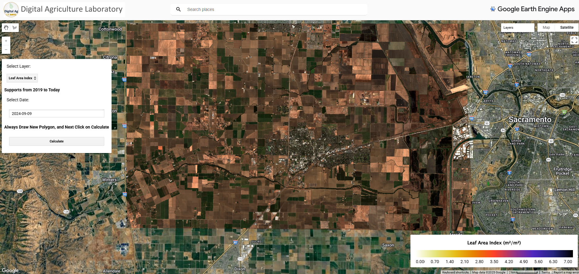
Sentinel-2 True Color Near Davis, California
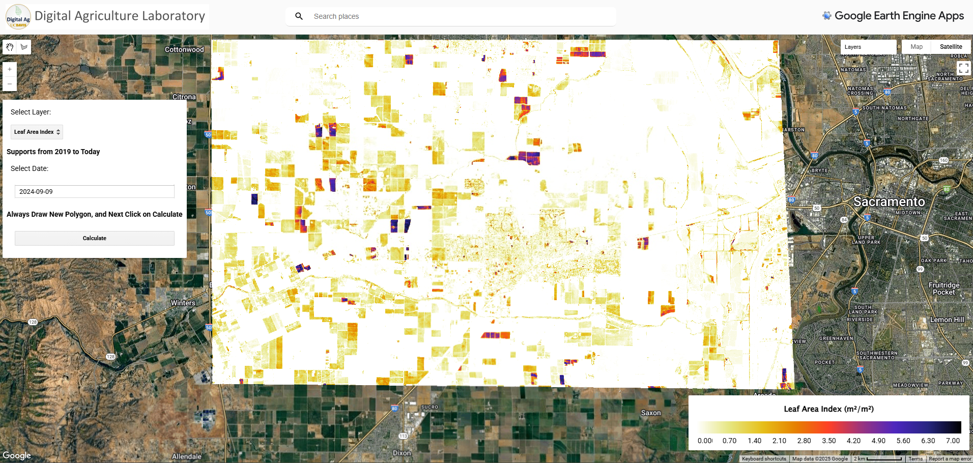
Leaf Area Index (LAI) Near Davis, California
Try the Interactive App
Use the embedded tool below to explore satellite-derived plant traits for your own fields and regions
Technical Information
Data Sources
- Sentinel-2 MSI Level-1C (Top-of-Atmosphere)
- Landsat 8 Collection 2 Level-1
- Google Earth Engine cloud computing platform
Available Plant Traits
- Leaf Area Index (LAI)
- Canopy Chlorophyll Content
- Canopy Water Content
- Canopy Dry Matter
- Leaf Chlorophyll Content
- Leaf Water Content
- Leaf Dry Matter
- Normalized Difference Vegetation Index (NDVI)
- Landsat 8 Thermal Data
Citation
Model Development:
Estévez, J., Salinero-Delgado, M., Berger, K., Pipia, L., Rivera-Caicedo, J. P., Wocher, M., ... & Verrelst, J. (2022). Gaussian processes retrieval of crop traits in Google Earth Engine based on Sentinel-2 top-of-atmosphere data. Remote Sensing of Environment, 273, 112958.
Application Development:
Interactive Google Earth Engine application developed by Mohammadreza Narimani at the Digital Agriculture Laboratory, University of California, Davis.
Resources & Links
About the Developer
Mohammadreza Narimani
PhD Candidate, University of California, Davis
Remote Sensing • Digital Agriculture • Google Earth Engine • AI for Environmental Monitoring
Developing satellite-based tools for precision agriculture and environmental monitoring at the Digital Agriculture Laboratory at UC Davis.
📧 mnarimani@ucdavis.edu
🎓 Google Scholar Profile